Monday, 5 November 2012

Speedy Gonzales (adapt) - Pat Boone

Having found the key to the draw-bridge this morning, and lowered it across the moat I was able to get out for the first time in 3 or 4 days. Mostly on private business which I approached via the cemetery, where Chaffinch were most numerous along with a few Blackbirds, Goldcrests and Robins while small numbers of Redwing flew overhead. Again we resort to the archive and continue the re-visit of previous trips to South America which, from e-mails received, seem to be to the liking of many.
Having traveled almost the full length of Ecuador, including a week on Galapagos, MIKE HUGHES and
I crossed the PERUVIAN BORDER at Machala and continued our journey, via the Pan-American Highway, to the northern city of Trajillo. There, we encountered some of the most bizarre hospitality including the company of the President of Peru himself, along with his lady wife, and most of the cities dignitaries but time doesn't allow for that story right now.
 It was a moonlit night in old Mexico (Peru). I walked alone between some old
adobe haciendas. Suddenly, I heard the plaintive cry of a young Mexican (Peruvian) girl. 
You better come home Speedy Gonzales
 We were in fact heading for
the ADOBE TEMPLES at Chan Chan, once the largest pre-Colombian city in South America, just five km west of Trujillo. Chan Chan covers an area of approximately 20 km² and once had a dense urban center of about 6 km². The vast adobe city was built by the Chimu around AD 850 and lasted until its conquest by the Inca Empire in AD 1470. It was the imperial capital of the Chimor until again conquered in the 15th century. It is estimated that around 30,000 people lived there.
Chan Chan was added as a UNESCO World Heritage Site in 1986, but the city is severely threatened by storms from El Nino which cause heavy rains and flooding on the Peruvian coast.
It is in a fertile, well-watered section of the coastal plain but the city's ruins are additionally threatened by earthquakes and looters. That isn't one pictured, that was at the time my Boss.
From there it was along haul by road to the capital Lima, from where we took a flight to Cuzco and the narrow gauge railway to Machu Picchu. No time to dwell there either as we moved on, again overland to
LAKE TITIKAKA the highest navigable lake in the world.
The UROS are a group of 40 or more floating islands made entirely from Reed
which are also used as a means of transport (boats),
Housing
and staple diet. We can report that the taste is very good.
Good natured people we were free to roam at will and take part in all that was going on
Only one 'lifer' as far as birds go on the lake, that being
GIANT COOT, the first of which was seen sizzling away in a frying pan. We can also report that they tasted disgusting!

Sunday, 4 November 2012

Hold The Line - Toto

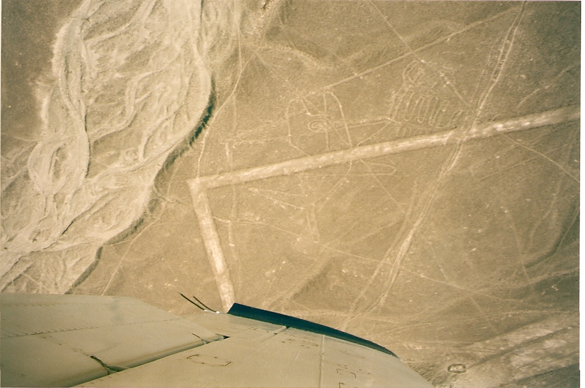
The Nazca Lines are a series of ancient geoglyphs located in the Nazca Desert in southern Peru. They were designated as a UNESCO World Heritage Site in 1994. The high, arid plateau stretches more than 80 kilometres (50 mi) between the towns of Nazca and Palpa on the Pampas de Jumana about 400 km south of the capital Lima. The 'lines' were created by the Nazca Indians between 400 and 650 AD and include hundreds of individual figures ranging in complexity from simple lines to stylized creatures. They are shallow designs made in the ground by removing the reddish pebbles and uncovering the whitish/grayish ground beneath, with the largest figures being over 200 metres (660 ft) across. Scholars differ in interpreting the purpose of the designs, but in general they ascribe religious significance to them. Other theories have been summarized as follows:- "the geometric ones could indicate the flow of water or be connected to rituals to summon water. The spiders, birds, and plants could be fertility symbols. Other possible explanations include irrigation schemes or giant astronomical calendars."
Mike Hughes and I boarding the light aircraft for the 45 minutes flight. Some of these designs may take a little deciphering, I will try to give guidance.
KILLER WHALE - almost dead centre, the open mouth is pointing upwards.
 GEOMETRIC SHAPES
RHOMBOIDS 
THE ASTRONAUT - on the slope of the lower left mount,
closer view of the most enigmatic of all the 'lines'.
DOG - left and above centre.
CONDOR - right.
CONDOR - closer view centre, bill downwards.
HUMMINGBIRD
SPIDER - almost centre.
SPIDER - left.
ALBATROSS - centre.
PARROT - head dead centre with open bill.
REPTILE & PARROT - centre.
HANDS left & TREE right.
TREE centre and WATCHTOWER top right corner. We did give the 'tower' a go, but you need a whole lot more elevation than that to make any sense of 'the lines'.
MONKEY - with 'endless' tail.
Due to the dry, windless, and stable climate of the plateau and its isolation, for the most part the lines have been preserved. Extremely rare changes in weather may temporarily alter the general designs, while in more recent years the lines have been deteriorating due to an influx of squatters inhabiting the lands.

Saturday, 3 November 2012

Going Underground - The Jam

A full day of preparing for the next adventure, including visits to the Foreign and Commonwealth Office Website checking advice and visa requirements of various countries, starting to allow me a decision on which ones to visit. Having 'cracked' the correct operation of the 'scanner' there was also the final batch of photographs to commit to the computer, which will now form much of the daily Blog content, as there is still much else to do and may not allow a lot of time in the 'great outdoors'.
Our first visits will be to the Town of NAZCA along with the adjoining Valley's and Plains and the Nazca Indian Community.
For many years CHAUCHILLA CEMETERY was looted by treasure hunters, who destroyed the place completely, taking away all the treasures the mummies kept in their tombs for centuries.
Grave robbers (that doesn't include me) just left behind the corpses, which can be seen today all over the ground.
Mike Hughes, my travel mate and ex boss, who accompanied me on 2 South American trips.
In addition to skulls and bones, visitors can also see several tombs centuries’ old, as well as long human hairs (on back wall), ceramic fragments and others remains scattered on the dessert surface.
 It is the only archaeological site in Peru, in which ancient mummies are seen in their original graves, along with ancient artifacts of the NAZCA INDIANS, dating back to 1000 AD.
 Something of a worrying visit on the way back to town, where we discovered one of the small family businesses still dedicated to the search for Inca Gold.
Here, tons of rock and sand are delivered and crushed in 'back-yard' production areas where most of the workforce are children. The dust is then passed through a series of 'rockers', propelled by these youngsters, then water and chemical treatment, including Mercury, to separate the precious metal. The toxic mix of this and hard labour is said to put great strain on the children's health.

Friday, 2 November 2012

Hato Pinero

Another full day 'confined to barracks', but all theoretically in a good cause. Awaiting Parcel Force, I set about committing even more photographs to the scanner/computer only to find after 300 images the system tripped and was left with an empty folder. On the strength of that here are a few more photos from South America, again from
the fabulous Nature Reserve that is HATO PINERO in Venezuela.
Even on that visit it had been decided that the Reserve would fall into Government hands, so heaven knows what the state of it might be these days.
COMMON PAURAQUE
CROWNED CARACARA
GREAT POTOO
GREY-NECKED WOODRAIL
The almost 'prehistoric' HOATZIN
The massive JABIRU
LESSER KISKADEE
PEARL KITE another dinky little Raptor.